A shear line interacting with the northeast monsoon is set to bring moderate to heavy rains across parts of the Visayas and Mindanao, while cooler air continues to sweep through Luzon, according to the Philippine Atmospheric, Geophysical and Astronomical Services Administration (PAGASA) on Saturday.
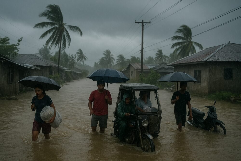
Forecasters said areas in Eastern Visayas and northeastern Mindanao could receive between 50 to 100 millimeters of rainfall over a 24-hour period — enough to trigger flash floods and landslides in vulnerable communities. No tropical cyclones or low-pressure areas are being monitored inside the Philippine Area of Responsibility.
Shear Line Brings Heaviest Rains to Eastern Visayas, Caraga
The brunt of the precipitation will fall on Eastern Samar, Leyte, Southern Leyte, Dinagat Islands, Surigao del Norte, Surigao del Sur, and Agusan del Sur, where the shear line remains active.
“There remains an active shear line impacting the eastern regions of the Visayas and Mindanao, contributing to precipitation over large areas of these regions,” said PAGASA meteorologist Loreidin de La Cruz-Galicia during a Saturday morning briefing.
The weather system forms where cold northeasterly winds from the amihan collide with warm easterly winds from the Pacific — much like two currents meeting in midstream, forcing air upward and wringing out moisture.
“The shear line — a weather system formed by the interaction of cold northeasterly winds and warm easterly winds — may continue to bring moderate to heavy rains over parts of the Visayas and Mindanao over the next 24 hours… 50 to 100 millimeters of rainfall, considered moderate to heavy,” de La Cruz-Galicia said.
Local government units in the affected areas have been advised to remain alert for possible flash floods and landslides, particularly in mountainous and low-lying barangays.
Amihan Keeps Luzon Cool and Cloudy
While the shear line drenches eastern sections of the country, the northeast monsoon continues to dominate Luzon and much of the Visayas, ushering in cooler temperatures and light, intermittent rains.
Cloudy skies with isolated light showers are expected over Cagayan Valley, Apayao, Kalinga, Mountain Province, Ifugao, Aurora, and Quezon. Metro Manila and the rest of Luzon are likely to experience generally fair to partly cloudy weather, with the amihan tempering daytime heat.
As of 4 p.m. Saturday, Quezon City recorded a maximum temperature of 29.9 degrees Celsius and relative humidity of 86 percent, according to PAGASA.
Earlier in the week, forecasters noted that the strength of the amihan had surged, extending as far south as sections of the Visayas.
“The northeast monsoon extends nearly to the Visayas at its lower section, where we can identify the axis of the shear line. This marks the area where the northeast winds meet the easterly winds,” de La Cruz-Galicia said in a February 19 briefing.
Sea Conditions Generally Manageable
Despite the active wind systems, PAGASA has issued no gale warnings. Moderate to strong northeast winds may produce waves of 1.5 to 2.8 meters along the eastern coasts of Southern Luzon and the Visayas. Elsewhere, seas are expected to remain slight to moderate, with wave heights ranging from 0.6 to 2.1 meters.
The absence of gale warnings provides relief to fisherfolk and small boat operators, who can continue operations with caution. Stable sea conditions also help maintain steady fish supplies in local markets.
Everyday Disruptions in Rain-Hit Communities
For residents in Samar, Leyte, and parts of Caraga, sustained rainfall could mean flooded farm plots, muddy village roads, and slowed public transport. In upland communities, saturated soil raises the risk of landslides, particularly in areas already weakened by previous rains.
In contrast, northern and central Luzon residents may welcome the cooler air after weeks of fluctuating temperatures. While light showers could cause slippery roads and minor delays, no significant weather disturbances are expected in Metro Manila.
No Storms on the Horizon
PAGASA reported that no tropical cyclones or low-pressure areas are currently being tracked within the Philippine Area of Responsibility. The prevailing weather systems — the shear line, amihan, and easterlies — are expected to persist over the next 24 hours.
Authorities continue to urge residents in high-risk areas to monitor official advisories and prepare for possible localized flooding or landslides, particularly where rainfall totals may accumulate quickly.
For now, the country remains under the steady influence of seasonal winds — cooler in the north, wetter in the east — a familiar February pattern shaped not by a brewing storm, but by the meeting of air masses overhead.