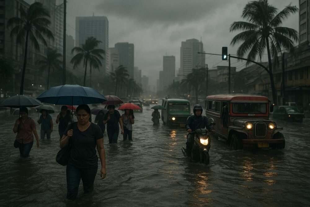
MANILA — A convergence of weather systems is drenching large parts of the Philippines this week, as the shear line, the northeast monsoon or amihan, and the easterlies combine to bring scattered rains, thunderstorms and cooler temperatures across the archipelago.
The Philippine Atmospheric, Geophysical and Astronomical Services Administration (PAGASA) said the most intense effects are concentrated in eastern sections of Northern and Central Luzon, where periods of moderate to heavy rain could trigger localized flash floods and landslides. While no tropical cyclone is currently being monitored within the Philippine Area of Responsibility, authorities have urged the public to remain vigilant.
Shear Line Soaks Eastern Luzon
At the heart of the unsettled weather is the shear line — the boundary where cold northeasterly winds meet warm easterlies. This atmospheric clash acts like a stalled front, squeezing moisture from the air and releasing it as steady rain.
“The shear line will mainly affect the eastern sections of Northern and Central Luzon, including Cagayan, Isabela, Aurora, Quezon, and Rizal. These areas will experience cloudy skies with scattered rains and isolated thunderstorms, which may trigger flash floods or landslides,” PAGASA said in a weather bulletin issued February 15.
The weather bureau has repeatedly warned residents in low-lying and mountainous communities to prepare for sudden flooding and slope failures, particularly during heavier downpours.
Amihan Brings Cooler Air, Choppier Seas
Reinforcing the damp conditions is a strong surge of the northeast monsoon, which began intensifying earlier this week.
“A strong surge of the northeast monsoon or Amihan is affecting Luzon and the Visayas this Wednesday, February 18, 2026,” PAGASA reported.
The amihan is expected to bring partly cloudy to cloudy skies with isolated light rains over the Ilocos Region, the Cordillera Administrative Region, Cagayan Valley and Aurora. While significant impacts are not anticipated in these areas, the monsoon is driving moderate to strong winds across Luzon and the eastern sections of Visayas and Mindanao.
Coastal waters in these areas are forecast to be moderate to rough, posing risks to small fishing vessels and sea travel. The cooler air has also lowered temperatures in northern and central parts of the country, offering relief from recent humidity but adding hazards to already rain-slick roads.
Easterlies Fuel Isolated Thunderstorms Nationwide
Further south, easterly winds are injecting additional moisture into the atmosphere, affecting Metro Manila, Western Visayas, Palawan, Basilan, Sulu, Tawi-Tawi and the rest of the country.
These areas can expect partly cloudy to cloudy skies with isolated rainshowers or thunderstorms, particularly in the afternoons or evenings. Though generally brief, thunderstorms may produce localized downpours capable of causing flash floods in urban centers with poor drainage.
Taken together, the three systems have created a patchwork of unsettled weather stretching from Luzon to Mindanao — a reminder that even in the absence of a typhoon, overlapping wind systems can disrupt daily life.
Commuters, Farmers and Fisherfolk Feel the Effects
In Metro Manila and nearby provinces, intermittent rains and isolated thunderstorms have complicated rush-hour commutes, slowing jeepney and tricycle services and increasing the risk of road accidents.
In agricultural provinces such as Cagayan and Isabela, farmers are watching conditions closely. Prolonged or heavy rainfall in upland areas raises the threat of landslides that can damage crops and disrupt transport routes, potentially affecting the supply of rice and vegetables to markets.
Along the eastern seaboard, fisherfolk face rough seas and gusty winds, limiting fishing activity and reducing fresh catch deliveries. For many coastal families, even a day or two of suspended operations can strain already tight incomes.
At the same time, the cooler amihan air has eased heat stress for outdoor workers and street vendors, though wet pavements and slippery surfaces create new safety concerns.
Authorities Urge Vigilance
Despite the absence of a cyclone threat, PAGASA has emphasized that non-typhoon weather systems can still pose serious hazards.
“PAGASA urged the public to continue monitoring official weather updates and take precautionary measures against possible hazards,” the agency said.
Under its mandate to provide hazard advisories, the weather bureau continues to issue regular bulletins as conditions evolve. Local government units in flood- and landslide-prone areas have been advised to remain alert, particularly in eastern Luzon where the shear line remains most active.
For now, forecasters say the layered weather systems will keep skies unsettled across much of the country — a stretch of gray days shaped not by a single storm, but by the complex choreography of seasonal winds.