Cloudy skies and scattered rains are set to persist across large swaths of the Philippines on Monday as three weather systems — the shear line, easterlies, and a weakening northeast monsoon or amihan — continue to influence much of the country, according to the Philippine Atmospheric, Geophysical and Astronomical Services Administration (PAGASA).
While no tropical cyclones or low-pressure areas are being monitored within the Philippine Area of Responsibility, state forecasters warned that parts of the Visayas and Mindanao remain vulnerable to moderate to heavy rains that could trigger flash floods and landslides. In contrast, much of Luzon, including Metro Manila, is expected to experience generally fair weather with isolated light rains.
Shear Line Brings Heaviest Rains to Eastern Regions
The most significant rainfall is tied to the shear line, a boundary where cold winds from the northeast monsoon collide with warm easterly winds from the Pacific. Like two air masses pulling against each other, the convergence creates unstable conditions that produce sustained cloud cover and rainfall.
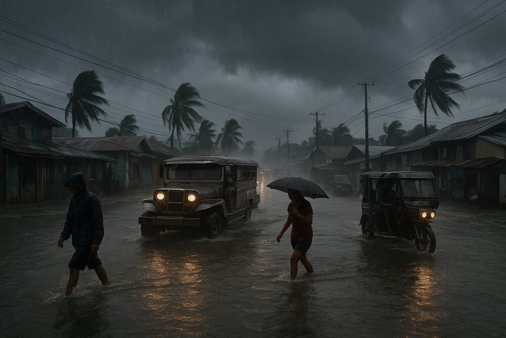
Areas expected to bear the brunt of this weather pattern include Eastern and Central Visayas, Misamis Oriental, Camiguin, Surigao del Norte, Dinagat Islands, and other parts of Mindanao. These regions have already recorded substantial precipitation in recent days, with 100 to 200 millimeters of rain observed in Surigao del Sur from Friday to Saturday. Other provinces — including parts of the Caraga region and Eastern Visayas — saw 50 to 100 millimeters of rainfall over the weekend.
PAGASA meteorologist Loreidin de La Cruz-Galicia said on Saturday: “There remains an active shear line impacting the eastern regions of the Visayas and Mindanao, contributing to precipitation over large areas of these regions… At the same time, the northeast monsoon, or amihan, continues to be felt across most of Luzon and parts of the Visayas.”
Forecasters caution that saturated soil conditions increase the risk of localized flooding and landslides, particularly in upland and flood-prone communities.
Amihan Weakens but Continues to Cool Luzon
Over Luzon and the remaining parts of the Visayas, the amihan continues to shape the weather, bringing cooler temperatures and mostly light rainfall.
In northern and eastern Luzon — including Cagayan Valley, Aurora, Quezon, and the Bicol Region — cloudy skies with light rains are expected. Metro Manila and the rest of Luzon will likely see partly cloudy to cloudy conditions with isolated light showers.
PAGASA weather specialist Veronica Torres explained on Sunday: “Amihan naman o northeast monsoon ‘yung nakakaapekto sa Luzon at nalalabing bahagi ng Visayas… Para naman sa lagay ng panahon sa Metro Manila at nalalabing bahagi ng Luzon, fair weather condition ang ating inaasahan na may mga tiyansa ng mga mahihinang pag-ulan.”
Daytime temperatures in parts of Metro Manila have hovered around 29.9 degrees Celsius, while early morning lows dipped near 23 degrees Celsius, providing relief from more typical dry-season heat.
Still, the monsoon’s influence is beginning to wane. “We anticipate that by tomorrow (Monday), the influence of amihan may lessen even more,” Torres added.
Easterlies Stir Isolated Thunderstorms in Mindanao
Beyond the shear line’s direct impact, warm easterly winds from the Pacific are affecting the rest of Mindanao. These winds are expected to bring partly cloudy to cloudy skies with isolated rainshowers or thunderstorms, particularly in the afternoons or evenings.
Though less intense than the shear line’s effects, localized thunderstorms may still produce brief downpours and gusty winds.
Sea Conditions Moderate, No Gale Warnings Raised
Marine conditions remain manageable, though not entirely calm. PAGASA reported moderate to strong northeast winds over the eastern sections of Southern Luzon and the Visayas, generating waves ranging from 1.5 to 2.8 meters. Elsewhere, winds will be light to moderate, with sea heights between 0.6 and 2.1 meters.
No gale warnings have been issued, and authorities are not monitoring any tropical cyclone formation within the Philippine Area of Responsibility.
Daily Life Disrupted in Rain-Affected Areas
For residents in the Visayas and parts of Mindanao, the weather may complicate the start of the workweek. Sudden downpours can slow commuter traffic, particularly along flood-prone roads and unpaved barangay routes. Fisherfolk along eastern coastlines may limit outings amid choppier seas, a move that can affect the supply of fresh fish in local markets.
In Luzon, the cooler air has eased daytime heat but may dampen outdoor commerce, from small vendors to construction crews navigating intermittent drizzles.
Underlying all forecasts is a reminder that even in the absence of a storm system, converging winds can produce significant rainfall. As PAGASA weather expert Leanne Loreto noted earlier this week, “Today and over the next three days, we can expect continued rainfall linked to this weather pattern.”
With the amihan gradually weakening and no major systems forming, conditions may stabilize later in the week. For now, however, residents in rain-affected areas are advised to remain alert to local advisories and prepare for possible sudden flooding or landslides as the shear line continues to shape the nation’s weather landscape.