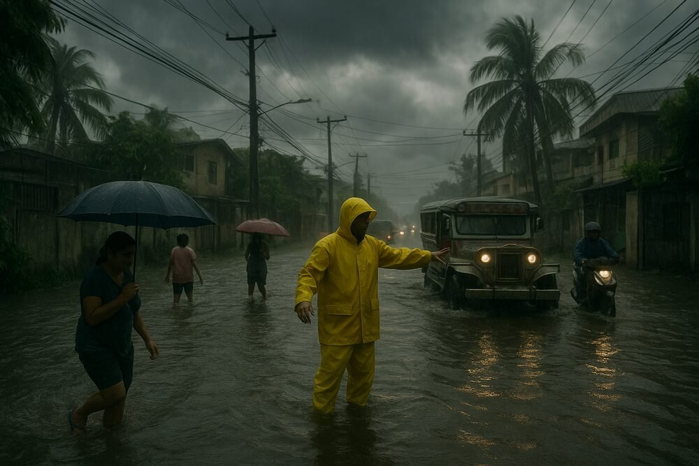
Cloudy skies and scattered rains are expected to drench parts of Luzon and the Visayas this week, as the Philippine Atmospheric, Geophysical and Astronomical Services Administration (PAGASA) tracks the combined effects of a shear line, the northeast monsoon or “amihan”, and prevailing easterlies. Weather officials have warned that localized heavy downpours may trigger flash floods and landslides, particularly in low-lying and mountainous communities.
In its 4 a.m. and 5 a.m. bulletins on Monday, PAGASA said the shear line is affecting the eastern sections of Northern and Central Luzon, while the amihan continues to push cooler winds across the northernmost provinces. Although no tropical cyclone threats loom, authorities urged residents to remain vigilant as intense thunderstorms can quickly turn dangerous.
Shear Line to Soak Eastern Luzon
The shear line—the boundary where cold northeast monsoon winds meet warm easterly air—will bring cloudy skies with scattered rains and isolated thunderstorms over Cagayan, Isabela, Aurora, Quezon, and Rizal.
“The shear line will mainly affect the eastern sections of Northern and Central Luzon, including Cagayan, Isabela, Aurora, Quezon, and Rizal. These areas will experience cloudy skies with scattered rains and isolated thunderstorms, which may trigger flash floods or landslides,” PAGASA said.
Weather forecasters added that severe thunderstorms could still pose risks even outside prolonged rainfall episodes. “PAGASA warned that severe thunderstorms may still cause flash floods or landslides.”
Communities perched along mountain slopes or near swollen rivers remain particularly vulnerable. In these areas, soil already loosened by previous rainfall can give way with little warning, turning hillsides into cascades of mud and debris.
Amihan Brings Cool Winds to Northern Luzon
Further north, the amihan continues to influence Ilocos Region, the Cordillera Administrative Region, and Cagayan Valley, including Ilocos Norte, Apayao, Batanes, and the Babuyan Islands.
These provinces can expect partly cloudy to cloudy skies with isolated light rains. While rainfall may be less intense than in shear line-affected areas, PAGASA noted that moderate to strong northeasterly winds will prevail over northern and eastern Luzon, producing moderate coastal waters.
For fisherfolk, this means tighter margins for small boats navigating choppier seas. For residents, the amihan’s arrival brings cooler mornings and evenings—sunrise was recorded at 6:20 a.m. and sunset at 6:01 p.m. on February 16—but also heightened caution in upland communities prone to landslides.
Easterlies to Bring Isolated Showers Nationwide
Outside the main weather systems, easterlies—warm winds from the Pacific—will affect Western Visayas, Palawan, Basilan, Sulu, Tawi-Tawi, Metro Manila, and the rest of the country.
These areas may experience partly cloudy to cloudy skies with isolated rainshowers or thunderstorms, mostly in the afternoon or evening. Though scattered, thunderstorms can unleash sudden, heavy downpours capable of flooding streets and overwhelming drainage systems, especially in densely populated urban centers.
Metro Manila commuters, already accustomed to traffic bottlenecks during rain, may face renewed disruptions as brief but intense showers coincide with rush hour.
No Tropical Cyclones, But Risks Remain
Despite the unsettled weather, PAGASA emphasized that no larger storm systems are currently forming.
“There are no low pressure areas (LPAs) being monitored for possible tropical cyclone formation as of 2 a.m. Monday,” the agency said.
The absence of a cyclone offers some relief to disaster management authorities. Still, PAGASA reminded the public that localized weather systems can be just as destructive on a smaller scale.
“Residents in affected areas were advised to remain vigilant for possible flooding and landslides, particularly in low-lying and mountainous areas.”
Preparedness Key Under Disaster Law
Under the Philippine Disaster Risk Reduction and Management Act of 2010 (Republic Act No. 10121), local government units are mandated to prepare for hydrometeorological hazards, from pre-emptive evacuations to real-time monitoring of rainfall and river levels.
With multiple weather systems interacting across the archipelago, officials are closely watching provincial hotspots where heavy rain earlier this month had already saturated the ground.
For now, the country faces not a single looming storm, but a patchwork of atmospheric forces—subtle on weather maps yet potent enough to disrupt livelihoods. In communities balancing on riverbanks and hillsides, even a passing thunderstorm can tip the scales.