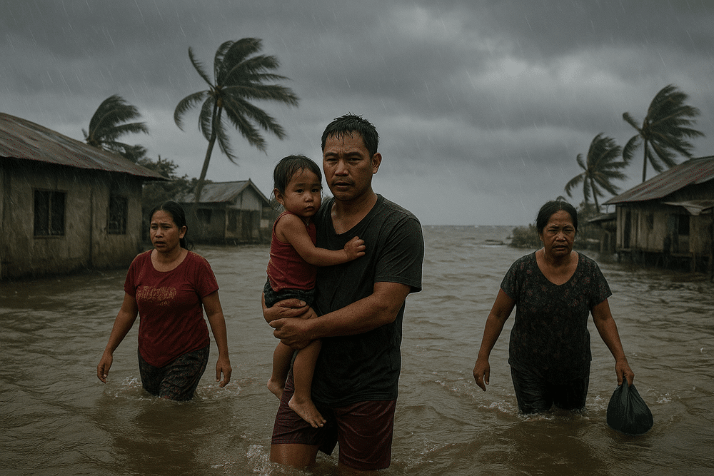
A Low Pressure Area (LPA) trough lingering east of the Philippines is poised to drench large parts of Eastern Visayas and Mindanao over the next 24 hours, raising the risk of flash floods and landslides in already vulnerable communities, the state weather bureau said.
The Philippine Atmospheric, Geophysical and Astronomical Services Administration (PAGASA) reported that the weather disturbance was located about 1,315 kilometers east of Eastern Visayas as of 2 p.m., packing maximum sustained winds of 55 kilometers per hour and gusts of up to 70 kph. The system is moving slowly north-northwestward and remains outside the Philippine Area of Responsibility (PAR).
Although it has yet to enter Philippine territory, its outer rainbands — described by forecasters as a trough — are already expected to bring widespread cloud cover and significant rainfall to the country’s eastern flank.
Heavy Rains Threaten Flood-Prone Areas
In its advisory, PAGASA said, “The trough of the tropical depression outside the Philippine Area of Responsibility (PAR) will bring cloudy skies and rain in the eastern sections of Visayas and Mindanao in the next 24 hours.”
Forecasters warned that “moderate to at times heavy rains may trigger flash floods or landslides.” Areas identified as most at risk include:
- Eastern Visayas
- Northern Mindanao
- Caraga
- Davao Oriental
- Davao de Oro
- Sulu
- Tawi-Tawi
For residents in low-lying barangays and mountainous terrain, the warning carries particular weight. In provinces like Caraga and Davao Oriental, where steep slopes meet frequent rainfall, even short bursts of intense rain can loosen soil and trigger landslides. In coastal and riverine communities, rapidly rising waters can isolate villages within hours.
No Immediate Threat to Luzon
While eastern sections of the Visayas and Mindanao brace for rain, Luzon faces no significant threat from the LPA. The Northeast Monsoon, or amihan, continues to influence the northern and central parts of the country, including Cagayan Valley, Bicol Region, Aurora, Quezon, and Metro Manila.
These areas are expected to experience generally fair to partly cloudy skies with isolated rain showers. PAGASA did not raise any severe weather alerts for Luzon in connection with the LPA.
Elsewhere across the archipelago, conditions will remain partly cloudy to cloudy, with localized thunderstorms possible.
Rough Seas to Disrupt Coastal Livelihoods
Beyond rainfall, the approaching trough is stirring coastal waters along the eastern seaboard. PAGASA warned of moderate to rough seas in the eastern coasts of Visayas, Mindanao, and parts of Luzon, driven by moderate to strong winds.
For small-scale fisherfolk — many of whom rely on wooden motorized boats — rough waters can mean lost income for days. In provinces such as Eastern Samar and Surigao, where communities depend on daily catch for both food and trade, suspended fishing operations ripple quickly through local markets.
Potential Development Into a Storm
The LPA remains outside PAR, but PAGASA has indicated the system bears monitoring. In an earlier update, the agency noted that the “LPA east of Mindanao may enter PAR Tuesday, may develop into storm in 24 hours.”
As of the latest advisory, however, forecasters emphasized that the system’s current impact is largely confined to rainfall from its trough. Its slow movement north-northwestward gives meteorologists time to assess whether it will intensify further.
Preparedness Measures Underway
Under Republic Act No. 10121, the country’s Disaster Risk Reduction and Management Act, local government units are mandated to respond swiftly to hydrometeorological threats. PAGASA’s early warnings allow provincial and municipal authorities to activate protocols, from pre-positioning relief goods to advising preemptive evacuations in landslide-prone zones.
For residents in affected areas, the message is straightforward: monitor official advisories, avoid crossing swollen rivers, and heed local evacuation orders if issued.
As the weather system edges closer, its rain-laden bands serve as a reminder that even storms beyond national borders can cast a long, wet shadow over the archipelago.


