MANILA — Metro Manila and the rest of the Philippines are entering March under a canopy of cloudy skies and isolated rains, as steady easterly winds signal the gradual shift toward the country’s hot-dry season. While downpours are expected to remain brief and scattered, the combination of rising temperatures, high humidity and intermittent showers is poised to shape daily life across the archipelago in the weeks ahead.
Forecast models show daytime highs averaging 32–33°C nationwide, with urban centers such as Manila potentially reaching 35°C (95°F). Nighttime temperatures will hover between 22–25°C, offering limited relief from what meteorologists describe as increasingly muggy conditions.
Easterlies Drive Seasonal Shift
The prevailing easterlies — warm winds blowing in from the Pacific Ocean — are steering moisture across the country, producing cloudy intervals and spotty rainfall from Luzon to Mindanao. These weather systems are typical at the tail end of the northeast monsoon, marking the transition into the summer months.
Rainfall totals for March are projected at a modest 24 to 75 millimeters, spread over just three to eight days of precipitation. On days with rain, accumulations are expected to be light, ranging from 0.1 to 0.8 millimeters, underscoring the predominantly isolated nature of the showers.
The country can expect an average of eight hours of sunshine daily, or roughly two-thirds of daylight hours, even as cloud cover builds intermittently. Sunrise will gradually shift earlier — from 6:13 a.m. at the start of March to 5:53 a.m. by month’s end — while sunsets will remain just after 6 p.m.
Heat and Humidity Intensify
Although rains will be sporadic, humidity levels are forecast to climb into what weather models categorize as “muggy” to “oppressive” territory, with dew points surpassing 21°C (70°F). Combined with light winds of 2 to 8 knots, the stagnant air is likely to magnify the sensation of heat, particularly in densely built urban areas.
The UV index is expected to reach extreme levels (11+), posing heightened health risks for those exposed to direct sunlight for prolonged periods. Coastal waters around Manila will stay warm at about 27°C, reflecting the broader seasonal warming trend.
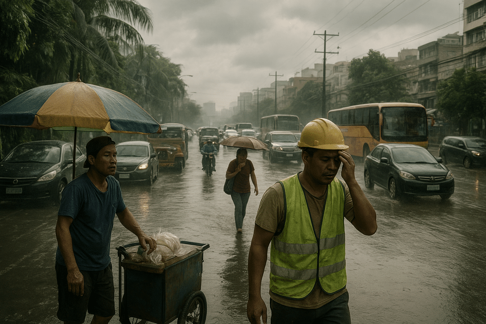
Commuters and Workers Feel the Strain
For residents of Metro Manila, where traffic congestion already stretches patience thin, even light rain can choke key thoroughfares. Isolated showers often lead to minor flooding in low-lying barangays in cities such as Manila, Navotas and Valenzuela, slowing jeepneys, buses and private vehicles navigating waterlogged streets.
Outdoor workers — from construction crews to market vendors and tricycle drivers — face a double burden: sudden drizzles that disrupt activity and temperatures climbing above 33°C under heavy humidity. Health experts routinely warn that such conditions increase the risk of heat exhaustion and dehydration, especially during peak afternoon hours.
In the provinces, farmers preparing fields for planting may welcome light moisture from passing showers. Yet the unpredictability of rainfall can also delay the drying of palay and create scheduling challenges for vegetable growers. Even marginal shifts in supply can influence the market prices of common produce such as kangkong and pechay.
Preparedness Framework in Place
Weather-related monitoring and advisories fall under the mandate of the Philippine Atmospheric, Geophysical and Astronomical Services Administration (PAGASA), operating in coordination with local government units nationwide. Broader disaster preparedness efforts are guided by Republic Act No. 10121, the Philippine Disaster Risk Reduction and Management Act of 2010, which outlines protocols for responding to natural hazards, including flooding triggered by isolated rains.
While the current outlook does not indicate severe weather disturbances or gale-force winds, authorities typically urge vigilance during transitional seasons, when rapid atmospheric shifts can produce localized downpours.
A Familiar March Pattern
Historically, March serves as a bridge between the cooler Amihan months and the onset of summer heat. Early forecasts for the first week show partly cloudy to sunny skies, with highs around 31–32°C. Mid-month conditions are expected to remain largely dry, before temperatures rise further toward the end of March, when isolated showers may reappear.
The pattern underscores a familiar paradox of the Philippine dry season: skies that threaten rain yet deliver mostly heat. For millions across the archipelago, March will likely unfold as a balancing act — between sun and shower, relief and discomfort — under the steady push of the easterly winds.